
$200
Description
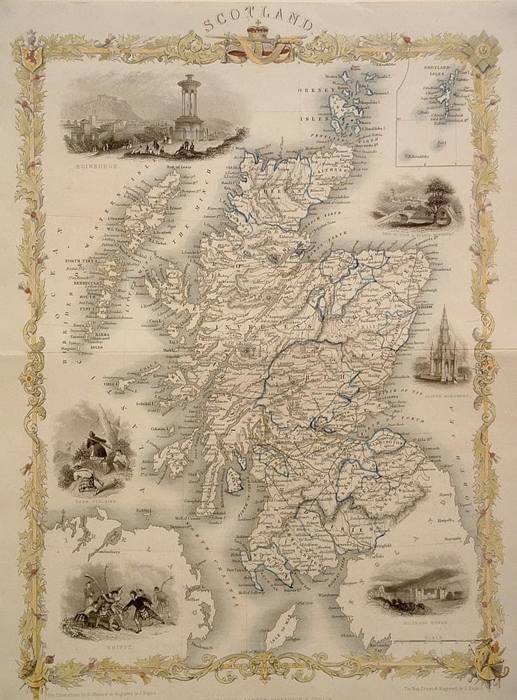
Classic Tallis detailed map surrounded by six vignettes depicting scenes from the time. All surrounded by an elegant border.
Clean and bright
Year1850
Item#1392
ConditionVG+
DESCRIBING A MAP’S CONDITION IS HIGHLY SUBJECTIVE. ART POST USES A RATING SYSTEM COMMON TO MAP DEALERS THROUGHOUT THE WORLD:
- Very Fine (VF) – Map is clean and bright with a strong image.
- Fine (F) – Map generally has a clean, sharp image. Flaws and repairs are noted.
- Very Good (VG) – Map has no significant imperfections, though paper quality and margin size may vary. Minor flaws such as wormholes, age toning, or a centerfold separation not affecting the image may be present.
- Good (G) – Map bears noticeable imperfections but remains in collectible condition. Foxing, a weak map image, and/or a wide centerfold separation are described.
All maps sold by Art Post are in collectable condition.
Size 14" x 10"
RegionBritish Isles
Bio
John Tallis (1838-51) founder of Tallis and Co., London map publishers who traded under various names: L. Tallis, Tallis & co, John Tallis, John Tallis & co. (London & New York) between 1838 and 1851. After 1850-51, their maps were published by the London Printing and Publishing Co., London and New York. The Illustrated Atlas of the World, published in 1849 with the maps and decorative vignette’s engraved and drawn by John Rapkin, was one of the last atlases to be truly decorated and is therefore highly prized.
These atlas maps were first published in serial form to a target audience for which the expense and hardship of travel was prohibitive. The progress of the nineteenth century brought swift and dramatic changes in public awareness of far-away places. Tallis' maps likely played an important role in this dramatic awakening. These maps not only provided up-to-date geographical knowledge, but also used vignette views within the map's design to show the native people and their occupations, cities and points of interest. The maps remind us of a cartographic tradition from the Dutch mapmakers of the seventeenth century with finely engraved decorative borders.
Rapkin’s maps included views drawn and engraved by a number of prominent artists. The maps were issued as a complete volume from 1851 until about 1865. Some of the maps were also published in other history books published by Tallis including the British Colonies and, without the vignettes, in geographical dictionaries and encyclopedias until about 1880.


984 G Willow Road | Northbrook IL 60062
(Willow & Waukegan Roads — near Whole Foods)
Questions?
Gallery: 847-272-7659 or Cell/Text: 847-732-8148
Weekdays: 10:30 to 5:30 | Sat: 10:30 to 5:00 | Sun: 1:00 to 4:00
Email: artpostgallery@comcast.net
Never miss an important event, new arrivals or special offerings.
Sign-up for
our periodic announcements: