$150
Description
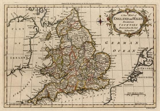
Bold engraving with a strong impression showing counties, towns, rivers, mountains and Hadrian’s Wall. Includes a compass rose and decorative cartouche. Engraved by George Rollos.
Year1759
Item#1398
ConditionVG+
DESCRIBING A MAP’S CONDITION IS HIGHLY SUBJECTIVE. ART POST USES A RATING SYSTEM COMMON TO MAP DEALERS THROUGHOUT THE WORLD:
- Very Fine (VF) – Map is clean and bright with a strong image.
- Fine (F) – Map generally has a clean, sharp image. Flaws and repairs are noted.
- Very Good (VG) – Map has no significant imperfections, though paper quality and margin size may vary. Minor flaws such as wormholes, age toning, or a centerfold separation not affecting the image may be present.
- Good (G) – Map bears noticeable imperfections but remains in collectible condition. Foxing, a weak map image, and/or a wide centerfold separation are described.
All maps sold by Art Post are in collectable condition.
Size 8" x 11"
RegionBritish Isles
Bio
John Barrow (1735–1774) was an English mathematician, naval historian and lexicographer. Nothing is known of his family. However, we do know that he was initially a teacher of mathematics and navigation aboard ships of the Royal Navy. He retired before 1750 and devoted himself to writing and compiling dictionaries and other works related to his knowledge of mathematics and science.
Barrow’s best known work was Navigatio Britannica (1750), a practical handbook of navigation and charts. It included an examination of nautical instruments and explained the recently introduced vernier scale.
In 1756, he published the New Geographical Dictionary anonymously in London. In the same year, he also published the first edition of his principal work, ‘A Chronological Abridgment or History of the Discoveries made by Europeans in the different parts of the world.’ In his introduction, Barrow shows a considerable knowledge of astronomical geography and the finding of latitude and longitude by the stars. This was an obvious tribute to his time as a teacher of navigation in the Royal Navy.

