
$225 (Unframed)
Description
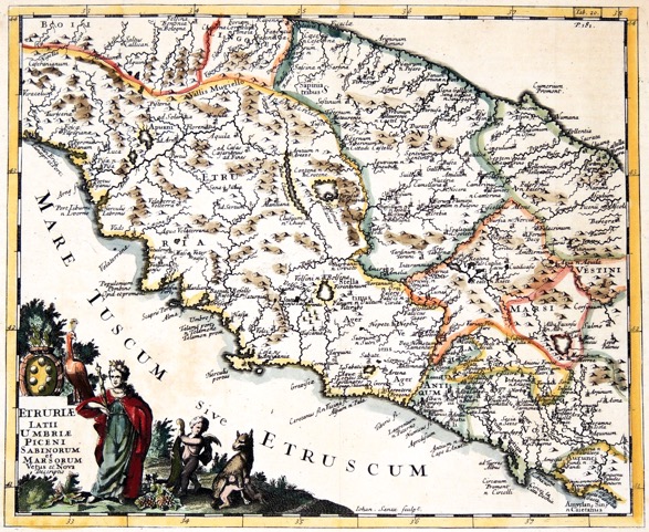
Engraved by John Senex, the map is centered on Perugia and Lake Trasimeno. It extends from Tuscany on the west coast to Umbria on the east coast. An allegorical title cartouche depicts a queen, a peacock, a putto with a cornucopia and Romulus and Remus suckling.
A dark impression. Some light toning in margins.
Year1711
Item#1817
ConditionVG
DESCRIBING A MAP’S CONDITION IS HIGHLY SUBJECTIVE. ART POST USES A RATING SYSTEM COMMON TO MAP DEALERS THROUGHOUT THE WORLD:
- Very Fine (VF) – Map is clean and bright with a strong image.
- Fine (F) – Map generally has a clean, sharp image. Flaws and repairs are noted.
- Very Good (VG) – Map has no significant imperfections, though paper quality and margin size may vary. Minor flaws such as wormholes, age toning, or a centerfold separation not affecting the image may be present.
- Good (G) – Map bears noticeable imperfections but remains in collectible condition. Foxing, a weak map image, and/or a wide centerfold separation are described.
All maps sold by Art Post are in collectable condition.
Size 9" x 12" (Unframed)
RegionEurope
Bio
Philipp Cluver (1580 – 1622) was born in Danzig and studied at Leyden and Oxford. An influential geographer, he published numerous pieces the most famous of which was Introductonius. The first edition of this popular geography book was published without maps. Many later editions with maps from several sets of plates followed his death and were published throughout the 17th and 18th Centuries. Most of the surviving maps attributed to him today are from Introductonius.


984 G Willow Road | Northbrook IL 60062
(Willow & Waukegan Roads — near Whole Foods)
Questions?
Gallery: 847-272-7659 or Cell/Text: 847-732-8148
Weekdays: 10:30 to 5:30 | Sat: 10:30 to 5:00 | Sun: 1:00 to 4:00
Email: artpostgallery@comcast.net
Never miss an important event, new arrivals or special offerings.
Sign-up for
our periodic announcements: