
Sold
Description
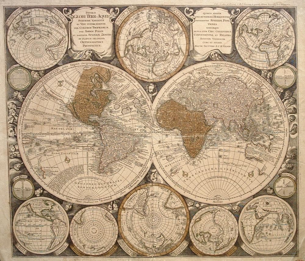
This remarkable 18th century map is dominated by a twin hemisphere world map which is surrounded by eight smaller maps. The island of California is depicted five times. In Asia, Japan is an odd shape that incorporates a huge Terra Yedso (Hokkaido). The coastlines of Australia and New Zealand are just barely appearing and New Guinea is shown twice. The map includes the tracks of several explorers, a background of clouds with numerous wind heads, lesser spheres and two full cartouches.
Mounted on linen backing and framed with linen; vertical and horizontal center fold creases.
Year1740
Item#1722
ConditionG
DESCRIBING A MAP’S CONDITION IS HIGHLY SUBJECTIVE. ART POST USES A RATING SYSTEM COMMON TO MAP DEALERS THROUGHOUT THE WORLD:
- Very Fine (VF) – Map is clean and bright with a strong image.
- Fine (F) – Map generally has a clean, sharp image. Flaws and repairs are noted.
- Very Good (VG) – Map has no significant imperfections, though paper quality and margin size may vary. Minor flaws such as wormholes, age toning, or a centerfold separation not affecting the image may be present.
- Good (G) – Map bears noticeable imperfections but remains in collectible condition. Foxing, a weak map image, and/or a wide centerfold separation are described.
All maps sold by Art Post are in collectable condition.
Size 22" x 25"
RegionWorld
Bio
Matthias Seutter (1678 – 1757) served as an apprentice to mapmaker J. B. Homann in the early 18th century. He established his own business as cartographer and publisher of maps and globes in Vienna and later in Augsburg. He was named Geographer to the Imperial Court and after dedicating his large atlas to Karl VI, Seutter was awarded the title of “Kaiserlicher Geograph”.
Attractive as Homann’s maps, Seutter’s work is noteworthy for its minute detail, color and large decorative cartouches. His greatest works were thought to be the Atlas Novus (1728 – 1745) and the Grosser Atlas (c. 1735).


984 G Willow Road | Northbrook IL 60062
(Willow & Waukegan Roads — near Whole Foods)
Questions?
Gallery: 847-272-7659 or Cell/Text: 847-732-8148
Weekdays: 10:30 to 5:30 | Sat: 10:30 to 5:00 | Sun: 1:00 to 4:00
Email: artpostgallery@comcast.net
Never miss an important event, new arrivals or special offerings.
Sign-up for
our periodic announcements: