
$625 (Framed)
Description
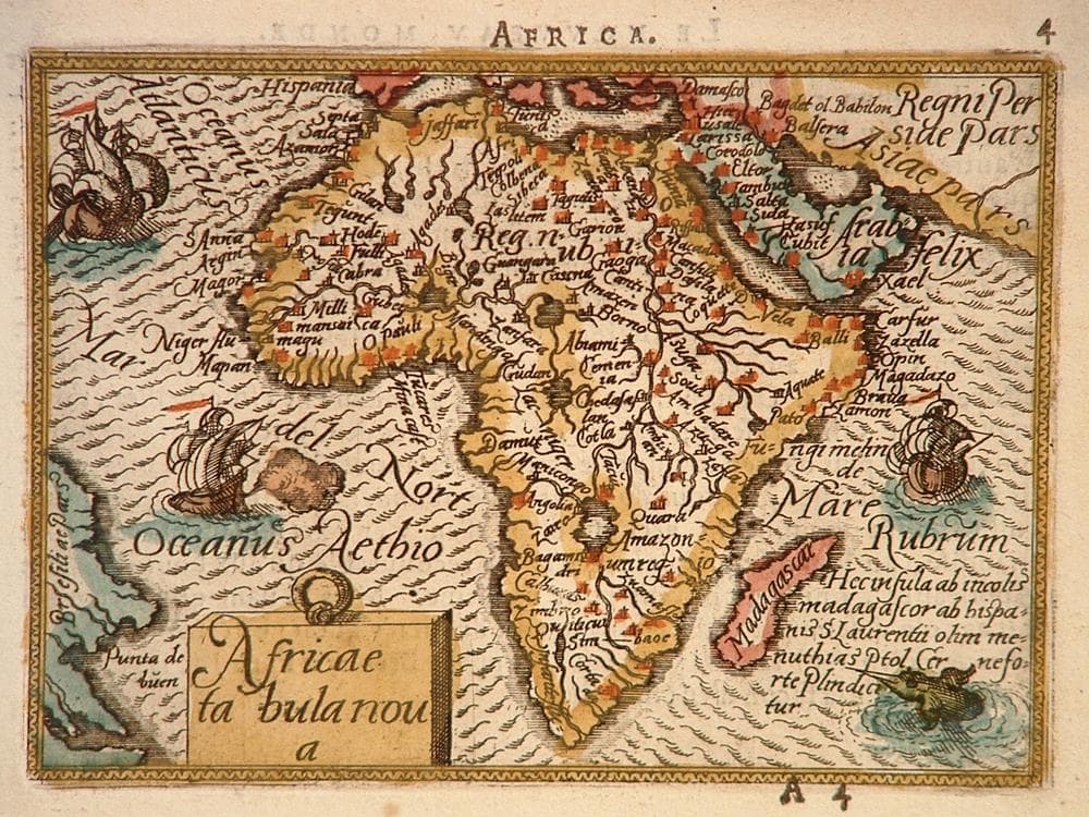
From the miniature Ortelius Atlas “Epitome”, which was the first pocket version of his Theatrum. Most notable change from prior maps is the elimination of Lake Zaflan as one source of the Nile.
Verso has two tape hinges.
Year1588
Item#1358
ConditionVG+
DESCRIBING A MAP’S CONDITION IS HIGHLY SUBJECTIVE. ART POST USES A RATING SYSTEM COMMON TO MAP DEALERS THROUGHOUT THE WORLD:
- Very Fine (VF) – Map is clean and bright with a strong image.
- Fine (F) – Map generally has a clean, sharp image. Flaws and repairs are noted.
- Very Good (VG) – Map has no significant imperfections, though paper quality and margin size may vary. Minor flaws such as wormholes, age toning, or a centerfold separation not affecting the image may be present.
- Good (G) – Map bears noticeable imperfections but remains in collectible condition. Foxing, a weak map image, and/or a wide centerfold separation are described.
All maps sold by Art Post are in collectable condition.
Size 12" x 13" (Framed)
RegionAfrica
Bio
Abraham Ortel (1527-1598), better known as Ortelius, was born in Antwerp and studied Greek, Latin and mathematics in his early years. Following the death of their father, he set up business with his sisters, as a book dealer and ‘painter of maps’. He also bought and sold general antiques and, from 1558 began purchasing multiple copies of maps, building up a large personal collection
In 1564, with the publication of a World Map in eight sheets (only one copy is known to still exist) followed by other individual maps, he started down a path that was to bring fame and fortune. He began gathering a collection of maps from contacts among European cartographers and had them engraved in uniform size and issued in 1570 as the Theatrum Orbis Terrarum (Atlas of the Whole World). Although others had published collections of 'modern' maps in book form before him, his Theatrum was the first uniformly sized, systematic collection of maps. As a result it is acknowledged as the first atlas. Interestingly, the term ‘atlas’ itself was not used until twenty years later by Mercator.
The Theatrum, with most of its maps elegantly engraved by Frans Hogenberg (1535-1590), was a huge success. It was reissued in 42 editions in Latin, Dutch, German, French, Spanish, Italian and English. Addenda were issued from time to time incorporating the latest contemporary knowledge and discoveries. After his death, his heirs transferred publication rights to Jan Baptiste Vrients who produced the later editions until he died in 1612. Unlike many of his contemporaries, Ortelius acknowledged his sources of information and in the first edition credit was given to eighty-seven different cartographers.
Apart from the modern maps in his major atlas, Ortelius himself compiled a series of historical maps known as the Parergon Theatri which appeared beginning in1579, sometimes as a separate publication and sometimes incorporated into updated editions of the Theatrum.


984 G Willow Road | Northbrook IL 60062
(Willow & Waukegan Roads — near Whole Foods)
Questions?
Gallery: 847-272-7659 or Cell/Text: 847-732-8148
Weekdays: 10:30 to 5:30 | Sat: 10:30 to 5:00 | Sun: 1:00 to 4:00
Email: artpostgallery@comcast.net
Never miss an important event, new arrivals or special offerings.
Sign-up for
our periodic announcements: