
$100
(Unframed)
Bio
Medium
Dimensions 8.5" x 11.5" (Unframed)
Styles Antique Maps
Subjects Maps Americas
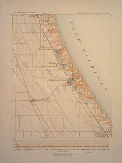
DescriptionContour map showing the ravines, streams and general topography of the North Shore of Chicago. Including rail lines, highways and towns Lake Forest, Highwood, Highland Park, Deerfield and Ravinia.


984 G Willow Road | Northbrook IL 60062
(Willow & Waukegan Roads — near Whole Foods)
Questions?
Gallery: 847-272-7659 or Cell/Text: 847-732-8148
Weekdays: 10:30 to 5:30 | Sat: 10:30 to 5:00 | Sun: 1:00 to 4:00
Email: artpostgallery@comcast.net
Never miss an important event, new arrivals or special offerings.
Sign-up for
our periodic announcements: