
$2,450
Description
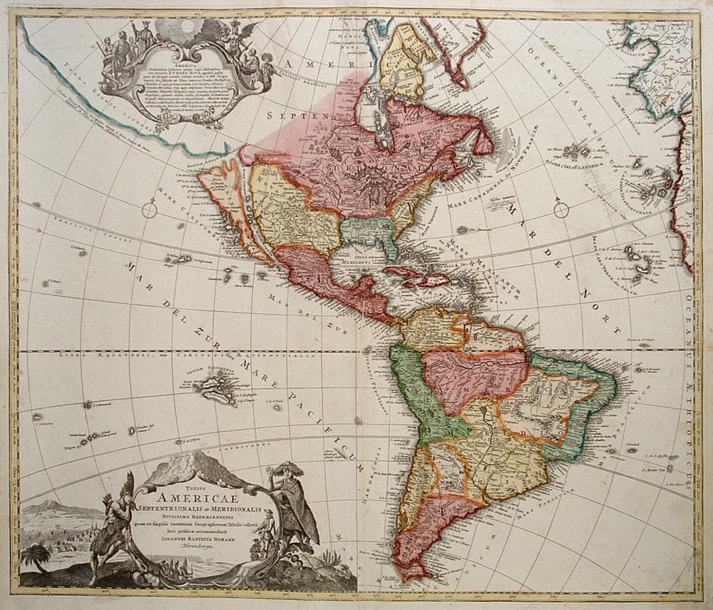
An early edition of Homann’s map of the Americas shows California as an island. Also shown is the mythical Terra Esonis Incognita, which forms a nearly continuous land bridge from North America to Asia. The Mississippi River and Great Lakes follow the reports of the early French Jesuit explorations. In South America, the Amazon and other interior features are beginning to take realistic form. The map is complete with two fine cartouches with scenes of natives, Jesuits, and European merchants.
Minor centerfold creases and a minor tear in top margin.
Year1730
Item#1724
ConditionVG
DESCRIBING A MAP’S CONDITION IS HIGHLY SUBJECTIVE. ART POST USES A RATING SYSTEM COMMON TO MAP DEALERS THROUGHOUT THE WORLD:
- Very Fine (VF) – Map is clean and bright with a strong image.
- Fine (F) – Map generally has a clean, sharp image. Flaws and repairs are noted.
- Very Good (VG) – Map has no significant imperfections, though paper quality and margin size may vary. Minor flaws such as wormholes, age toning, or a centerfold separation not affecting the image may be present.
- Good (G) – Map bears noticeable imperfections but remains in collectible condition. Foxing, a weak map image, and/or a wide centerfold separation are described.
All maps sold by Art Post are in collectable condition.
Size 20" x 23.5"
RegionAmerica's
Bio
Following the long period of Dutch domination, the Homann family became the most important map publishers in Germany in the eighteenth century. The business was established by Johann Baptist Homann (1663-1724) in Nuremberg circa. 1702. Soon after publishing his first atlas in 1707 he became a member of the Berlin academy of Sciences and in 1715 he was appointed Geographer to the Emperor. After the founder's death in 1724, the firm continued under the direction of his son until 1730. It was then bequeathed to his heirs on the condition that it continued to trade under the name Homann Heirs. The firm remained in being until the 19th century and had a wide influence on map publishing in Germany.
The Homman's produced a Neuer Atlas in 1714, a Grosser Atlas in 1737, and an Atlas Maior with about 300 maps in 1780. They also issued a special Atlas of Germany with full sized plans of principal cities, school atlases and an Atlas of Silesia in 1750 with 20 maps. Apart from the atlases, the firm also published a very large number of individual maps.


984 G Willow Road | Northbrook IL 60062
(Willow & Waukegan Roads — near Whole Foods)
Questions?
Gallery: 847-272-7659 or Cell/Text: 847-732-8148
Weekdays: 10:30 to 5:30 | Sat: 10:30 to 5:00 | Sun: 1:00 to 4:00
Email: artpostgallery@comcast.net
Never miss an important event, new arrivals or special offerings.
Sign-up for
our periodic announcements: